False Creek
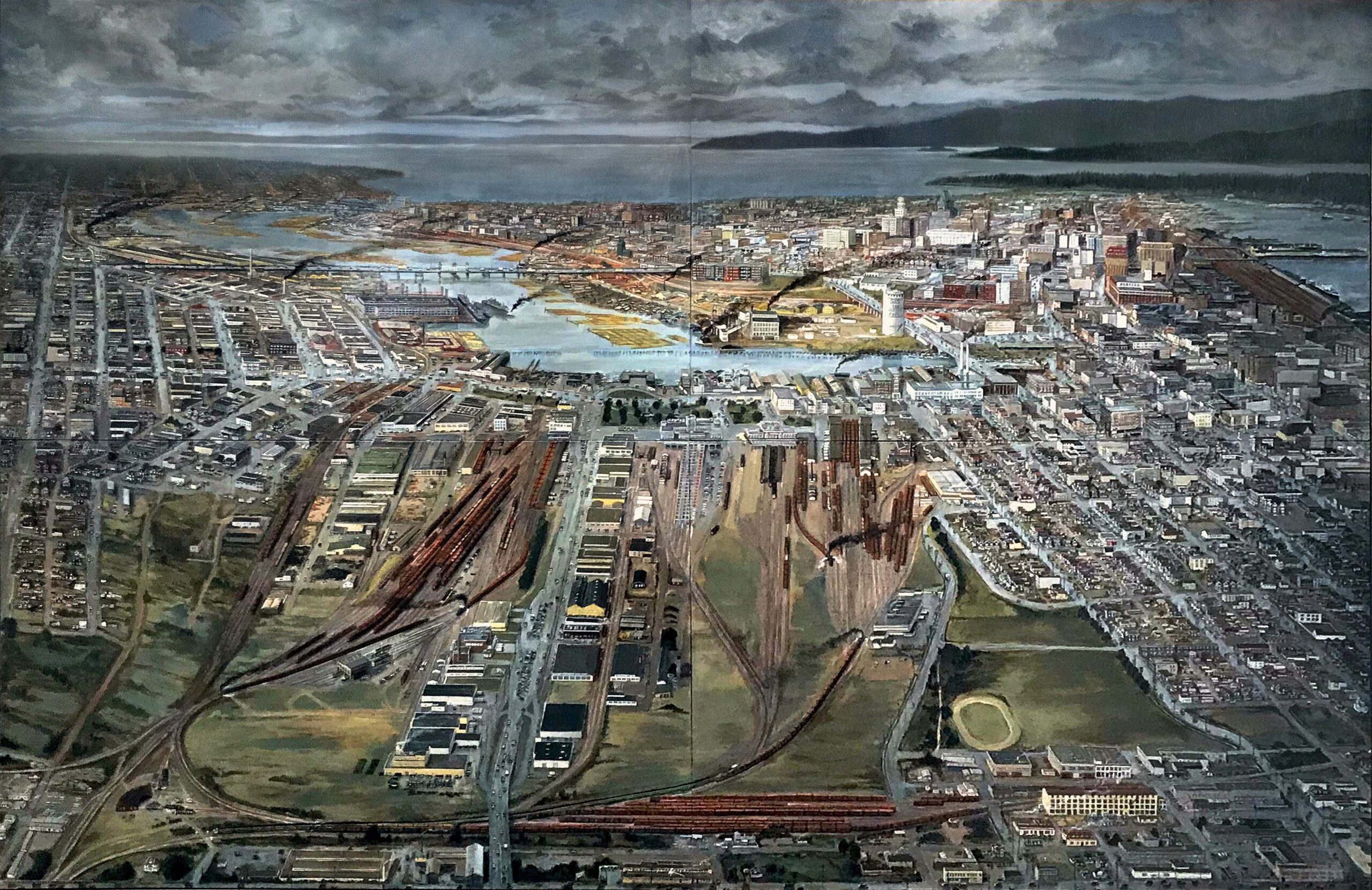
“False Creek” depicts the entire False Creek Flats looking west from Clark Drive (which runs the very bottom of the painting). At the far right is the intersection with Venables and far left is where Great Northern Way would eventually be.
I’ve set it in the early 1950s – at the height of the area’s industrial activity. It’s a time of post-war transition and construction (from steam to diesel in the railways, and the replacement of old infrastructure seen in the construction of the new Granville Bridge in the distance). Within a few years the city skyline would change dramatically with new office towers – at this time it hadn’t really changed much since the 30s.
The challenge laying out this piece was to include the entire eastern flats while showing as much of the waterfront industry and downtown as possible. The West End and Kitsilano weren’t as important, while the working class neighbourhoods in Strathcona and Mount Pleasant were important to me. This was an industrial city where people worked and lived in close proximity. To achieve this, I have a curved horizon: in the lower half of the painting we’re looking downward, by Main St. the horizon comes down a bit, at Cambie it tilts more, and so forth. This achieves the same effect as tilting your head up and down if you were looking at the view from above. No camera could achieve this and it’s tricky to make all the perspectives and streets line up – but gives us a much more in-depth view. I also had to warp the view from left to right to show is the entire False Creek (which bends quite far around Yaletown) – again, it meant a lot of perspective tricks to make the historic city line up but now we can see the entire thing. This warping of horizons and vanishing points are techniques I use to give us views impossible with photography. Finally, I compress the proportions and scale – buildings are larger than they would be with simple perspective. They do get smaller as they recede into the distance, but not as quickly as in real life. In other words, the Hotel Vancouver and the downtown core would be much smaller if this was a photograph. This requires quite a bit of finessing with relative proportions – buildings must be in their correct locations and proportions relative to each other – so I make up the differences by reducing the sizes of things that aren’t that important – parking lots and less interesting buildings get reduced a bit. This gives us an experience much closer to actual memory – we know there was a parking lot but don’t care what size it was, while the major landmarks we remember as imposing and want to see in detail!
This view is based on hundreds of historic photos, city engineering maps of the period, fire insurance maps (which show the footprint of every building in the city and their construction) and city aerial photos looking straight down, which were very useful for Strathcona! As well as the VPL Special Collections and Vancouver Archives, I called on my network of historian friends so was able to find wonderful photos in private collections and from as far as the Goodyear Tire company archives in Akron! I’ve also had guests over to offer insights, such as a gent in his 90s who operated tugs in False Creek in the 1940s. He gave the painting his thumbs up – said it was just like he remembered it – which means a lot to me!